هەواڵ
The New Map of Western Kurdistan (Rojava)
بڵاوکراوەتەوە لە : 3 شوبات 2026
قەبارەی دەقەکان
قەبارەی دەقەکان
هەواڵ
بڵاوکراوەتەوە لە : 3 شوبات 2026
قەبارەی دەقەکان
قەبارەی دەقەکان
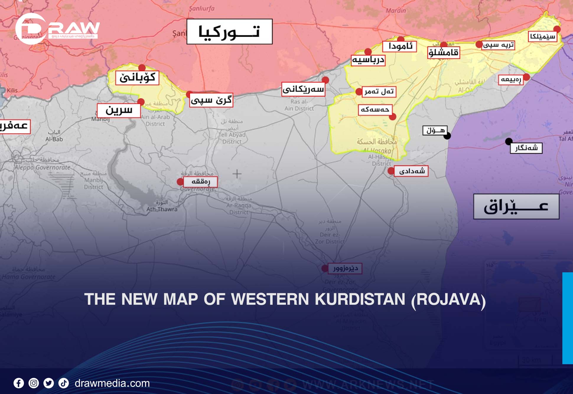
At present, all Kurdish territory in the regions of Kobane, Hasakah, and Qamishli is under autonomous administration, except for Afrin, Serekaniye (Ras al-Ayn), and Tal Abyad (Girê Spî), which were occupied five years ago.
The total area currently under the control of the Autonomous Administration / SDF (HSD) is approximately 20,000 square kilometers, out of a total 33,000 square kilometers of Western Kurdistan.
At present, 7 oil and gas fields, 1,500 oil wells, and 25 gas wells remain under autonomous control. However, most villages along the borders of Western Kurdistan have undergone Arabization. Out of 1,717 villages, more than 1,000 are Arab-populated, while fewer than 700 remain Kurdish.
Out of a population exceeding 4 million in Rojava, more than 2.5 million people live under autonomous administration in Hasakah, Kobane, and Qamishli, while approximately 1.5 million people live under the control of Turkey-backed groups and the Syrian government in Afrin, Sheikh Maqsoud, Serekaniye, and Tal Abyad, areas that were previously occupied.
The 15-day conflict between the SDF, the Syrian Army, and armed Syrian groups reshaped the control map in Syria. As a result, the SDF lost control of all Arab-majority regions, retaining authority only in Kurdish-majority areas, with a remaining area of approximately 20,000 square kilometers.
Syria’s total area is 185,180 square kilometers. Before the events in Sheikh Maqsoud and Ashrafiyah, territorial control was as follows:
Syrian Government: 69.3%
SDF: 27.8%
Druze regions: 2.8%
Golan Heights: 0.1%
Before the conflict that began on January 6, 2026, the total SDF-controlled area was 51,961 km², distributed across the governorates of Hasakah, Deir ez-Zor, Raqqa, and Aleppo.
Hasakah: 23,334 km²
Raqqa: 19,616 km²
Aleppo: 18,500 km²
Deir ez-Zor: 33,060 km²
Total area: 23,334 km²
About 3,000 km² in the north is controlled by Turkey-backed groups. Approximately 17,000 km² remains under SDF control, including Hasakah city, Qamishli, Derik, and Amuda.
Total area: 19,616 km²
Previously, 11,700 km² were under SDF control, including Raqqa city and Tabqa. All of these Arab-majority areas have now been lost.
Total area: 33,060 km²
Previously, 14,527 km² (including the governorate center) were under SDF control. All of this Arab-majority territory has now been lost, including most oil and gas fields.
Total area: 18,500 km²
Previously, about 5,400 km² were under SDF control, including Kobane, Sheikh Maqsoud, Ashrafiyah, Deir Hafer, and Maskanah.
Currently, only 3,250 km² remain under SDF control, mainly Kobane and its countryside.
Approximately 20,250 square kilometers
Western Kurdistan has become fragmented. Since the 1962 census, which stripped many Kurds of citizenship, and through systematic Arabization, most villages in Rojava have become Arab-populated.
According to research by Imad Abdul-Hussein Jaf, the area of Western Kurdistan exceeds 33,150 km², stretching 822 km from the Tigris River to Afrin.
According to 2023 statistics, Rojava’s population is 4,518,166, including:
2,297,879 males
2,220,287 females
Administratively, Rojava is divided among the governorates of Hasakah, Aleppo, and Raqqa.
Afrin District – occupied by Turkey since 20 January 2018
Serekaniye District – occupied since 2019
Tal Abyad District – occupied since 2019
Kobane District – under autonomous administration
Qamishli District – under autonomous administration
Derik District – under autonomous administration
Hasakah District – under autonomous administration
Hasakah, Qamishli, Kobane, Derik, Amuda, Tal Tamr, Ain Diwar, Tel Kocher, and surrounding towns and villages.
Afrin, Tal Abyad, Serekaniye, Sheikh Maqsoud, and Ashrafiyah.
Afrin: 900,000 – 1,000,000
Sheikh Maqsoud & Ashrafiyah: 500,000
Kobane: 600,000
Tal Abyad & Serekaniye: 500,000
Hasakah & Qamishli: 1,800,000
Other areas: 800,000
Total population under autonomous administration: over 2.5 million.
Approximately 1,500 oil wells and 25 gas wells, including:
Rumailan Oil Field
Alian Oil Field
Suwaydiyah Oil Field
Karachok Oil Field
Rumailan Gas Field
Maashouq Oil Field
Tal Adas Oil Field
Suwaydiyah Oil Field
Production capacity: 116,000 barrels/day
Wells: 685
Reserves: 8 billion barrels
Rumailan Oil Field
Wells: 460
Reserves: 1.3 billion barrels
Production: 90,000 barrels/day
Rumailan Gas Field
Production: 2 million cubic meters/day
Supplies power plants and households
Supports Suwaydiyah gas station (the largest in the region)
Karachok Oil Field
Wells: 450 (200 active)
Reserves: ~1 billion barrels
Oil production: 45,000 barrels/day
Gas production: 200–300 thousand m³/day
Yusufiyah Oil Field
Production: 25,000 barrels/day
Wells: 22